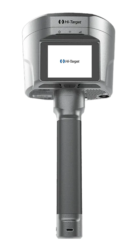
Deskripsi
Kini telah hadir Hi-Target V700S yaitu alat inovatif yang mengintegrasikan teknologi SLAM dan RTK untuk pengukuran presisi hingga tingkat sentimeter, baik di area terbuka maupun lokasi sulit seperti lorong sempit, bawah jembatan, dan dalam ruangan.
Fitur utama dari Hi-Target V700S SLAM RTK
V700S dilengkapi teknologi Laser Reverse Positioning yang memungkinkan pemetaan akurat tanpa sinyal GNSS, berkat kombinasi pemetaan visual dan pemrosesan laser real-time tanpa titik kontrol tambahan.
Integrasi RTK dan SLAM secara otomatis menghasilkan output koordinat BLH dan NEZ, menghilangkan kebutuhan kalibrasi ulang. Surveyor dapat memindai langsung di lapangan dengan tetap menjaga presisi.
Fitur pengambilan koordinat jarak jauh melalui foto memungkinkan pengukuran di area berbahaya atau sulit dijangkau tanpa kontak langsung.
Untuk pekerjaan volume tanah, V700S menghasilkan point cloud 3D padat dan detail, mendukung efisiensi dalam proyek galian dan manajemen material.
Dengan chip GNSS 1.408-channel dan teknologi anti-jamming adaptif, perangkat ini tetap stabil di area dengan gangguan sinyal. Proses pascapengukuran didukung software desktop untuk pembersihan data hingga analisis volume secara efisien.
Spesifikasi Hi-Target V700S SLAM RTK
GNSS Configuration
- Channel: 1408
- GNSS Signal:
- GPS: L1C/A, L1C, L2P(Y), L2C, L5
- BDS: B1I, B2I, B3I, B1C, B2a, B2b
- GLONASS: L1, L2, L3
- GALILEO: E1, E5a, E5b, E6
- QZSS: L1, L2, L5, L6
- NavIC: L5
- SBAS: L1, L2, L5
- PPP: B2b-PPP, E6-HAS
- Output format: ASCII: NMEA-0183, Binary
- Output rate: 1Hz~20Hz
- Static data format: GNS, Rinex
- Real Time Kinematic: RTCM2.X, RTCM3.X
- Network Mode: VRS, FKP, MAC, Support NTRIP protocol
System Configuration
- Operation system: Linux
- Storage: Circulating 512GB ROM
Accuracy and Reliability
- High-Precision Static: H: 2.5 mm + 0.1 ppm RMS, V: 3.5 mm + 0.4 ppm RMS
- Static and Fast Static: H: 2.5 mm + 0.5ppm RMS, V: 5 mm + 0.5ppm RMS
- PPK: H: 8mm + 1ppm RMS, V: 15mm + 1ppm RMS
- PPP: H: 10cm, V: 20cm
- Code Differential GNSS Positioning: H: ±0.25m+1ppm RMS SBAS: 0.5m (H), 0.85m (V), V: ±0.5m+1ppm RMS
- Real Time Kinematic (RTK): H: 8mm+1ppm RMS Initialization time: Typically <10s, V: 15mm+1ppm RMS Initialization reliability: Typically > 99.9%
- Tilt Survey Performance: 8mm+0.3mm/°tilt
- AR Stakeout: Support
- Image measurement: A single photo can acquire multiple point coordinates, with an accuracy of better than 5cm within 15 meters
- Real-time accuracy evaluation: Supports
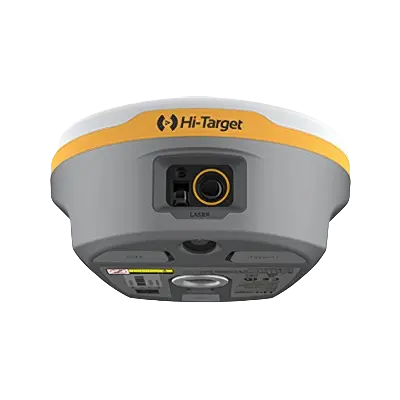
Camera
- Pixel: 3 Professional HD Cameras
- Function: Support AR stakeout, image measurement, working distance 2~15m
Laser Scanner
- Range: 0.1~ 40m@10%, 0.1~ 70m@80%
- Point Measurement Rate: 200,000 pts/sec
- Laser product classification: Class 1 Eye Safe
- FOV: H: 160°, V: 59°
IMU
- Update rate: 200Hz
Communication
- I/O Interface: USB type C port; SMA antenna port; Nano SIM card slot
- Network: TDD-LTE,FDD-LTE,GSM
- WiFi: IEEE 802.11a/b/g/n/ac/ax,2.4GHz/5GHz,Wifi hotspot
- Bluetooth: Bluetooth 5.2
- Internal UHF Radio:
- Power:0.5W/1W Adjustable Frequence: 410MHz~470MHz
- Protocol: HI-TARGET, TRIMTALK450S, TRIMMARK III, SATEL-3AS, TRANSEOT, etc.
- Channel: 116(16 scalable)
Sensor
- Electronic bubble: Supports
- Tilt Survey: Built-in High-precision IMU Module
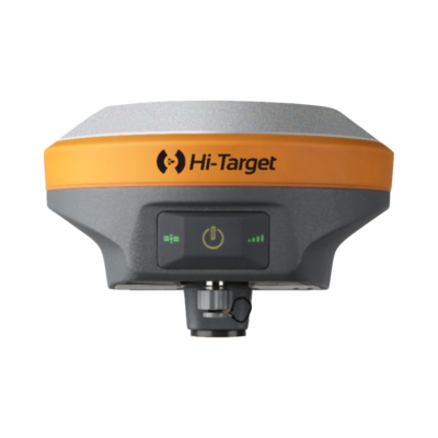
Control Panel
- Physical button: Single button
- Display: 2.8 inch, 480×640 pixel touchable screen
- LED lights: Mode, Accuracy, Network
Application
- Advanced function: NFC, WebUI, Firmware upgrade via U-disk
- Intelligence application: Intelligent Voice, Self-check
- Remote service: Message push, online upgrade, remote control
Physical
- Power:
- Lithium battery, portable charger
- RTK rover(UHF/Cellular): up to 10 hours, SLAM mode: up to 5 hours
- USB 45W fast charging, fully charged in 2 hours
- Size: fully charged in 2 hours
- Weight: 68kg
- Power:
Environments
- Water/dustproof: IP64
- Humidity: 100% non-condensing
- Operation temperature: -20°C~+55°C
- Storage temperature: -40°C~+70°C
Kelengkapan
- 1x V700S GNSS Receiver
- 1x Battery
- 1x Qpad X9 Tablet
- 1x Radio Receiving Antenna
- 1x Survey Pole Hi-Target (new logo) 2.2m
- 1x Power adapter
- 2x USB data cable
- 1x Double-socket tablet mount
- 1x Tablet bracket
- 1x Tablet mount
- 1x Fixing screw
- 1x Control Point Benchmark
- 1x Survey Benchmark
- 1x Rover plastic case
- 1x Certificate of quality
- 1x Warranty card
- 1x Plastic case PVC label (Hi-Target)
- 1x Envelope
- 1x Hi-Target software
- 1x Hi-LiDar (optional)
Layanan purna jual
- Garansi servis 1 tahun
- Gratis training alat
- Gratis pengiriman dan juga COD khusus Kota Manado dsk
Alasan mengapa memilih Indosurta?
- Lebih dari 10 Tahun berpengalaman di dunia survey dan pemetaan.
- Setiap pembelian alat di Indosurta akan mendapatkan gratis kalibrasi selama 1 tahun, dan gratis pelatihan alat.
- Produk berkualitas dan juga bergaransi resmi
Tentu saja kami juga menerima pengiriman keluar Manado
Lalu kami juga tersebar luas di kota – kota seluruh Indonesia, seperti :
- Balikpapan
- Makassar
- Batam
- Surabaya
- Palembang
- Medan
- Manado
- Cikarang
- Semarang
- Banjarmasin
- Kendari
- Jakarta
- Samarinda