Deskripsi
Download Brosur: Brosur GPS Geodetik Hi-Target V90 RTK GNSS
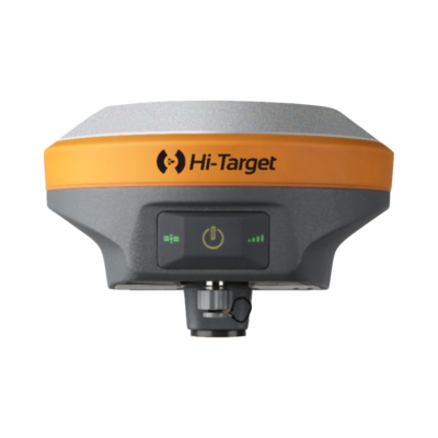
GPS Geodetic Hi-Target V90 Plus GNSS RTK memiliki desain berteknologi tinggi dan terintegrasi penuh, yang berukuran nyaman adalah salah satu pilihan paling fleksibel untuk tugas pengukuran apa pun.
Kemudian di bangun dengan Sistem operasi Linux 3.2.0 didalamnya, menghasilkan beberapa aplikasi canggih yang dimuat sebelumnya seperti survei kemiringan, kalibrasi gelembung elektronik, NFC, dan suara buatan sendiri. Sistem GNSS V90 Plus sendiri menyediakan kemudahan untuk surveyor di industri operasi GNSS.
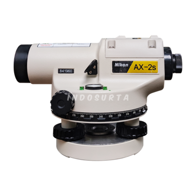
Beli juga : Automatic Level Waterpass Sokkia B40A
GPS Geodetic HI Target V90 Plus tersedia di Kota Ambon Maluku dan sekitarnya dengan harga terjangkau dan juga bergaransi resmi 1 tahun. Untuk pembelian silahkan hubungi kami atau bisa juga datang ke toko alat survey kami.
Spesifikasi GPS Geodetic Hi-Target V90 Plus GNSS RTK
Satellite Signals Tracked Simultaneously
- 1408 Channels (only for gnss manufactured in 2024 and above)
- GPS: Simultaneous L1C/A, L2C, L2E, L5
- GLONASS: Simultaneous L1C/A, L1P, L2C/A (GLONASS M only), L2P
- BDS: B1, B2
- Galileo: Simultaneous E1 BOC, E5A, E5B, E5AltBOC
- SBAS: L1 C/A, L5
- 550 Channels (Optional)
- GPS: L1C/A, L1C, L2C, L2P, L5
- GLONASS: L1C/A, L2C, L2P, L3, L5
- BeiDou: B1, B2, B3
- Galileo: E1, E5A, AltBOC, E5a, E5B, E6
- IRNSS: L5
- SBAS: L1, L5
- QZSS: L1C/A, L1C, L2C, L5, L6
- L-band: Up to5 channels
- TerraStar Correction Services
Positioning Performance
- Hot Start: Typically< 10s
- Cold Start: Typically< 15s
- High Precision Static
- Horizontal: 2.5 mm + 0.1 ppm RMS
- Vertical: 3.5 mm + 0.4 ppm RMS
- Static and Fast Static
- Horizontal: 2.5mm + 0.5 ppm RMS
- Vertical: 5 mm + 0.5 ppm RMS
- Post Processing Kinematic (PPK / Stop & Go) GNSS Surveying
- Horizontal: 8mm+1ppm RMS
- Vertical: 15mm+1ppm RMS
- Initialization time: Typically 10 min for base and 5 min for rover
- Initialization reliability: Typically > 99.9%
Real Time Kinematic (RTK) Surveying
- Single Baseline
- Horizontal: 8mm+1ppm RMS
- Vertical: 15mm+1ppm RMS
- Code Differential GNSS Positioning
- Horizontal: 25cm+1ppm RMS
- Vertical: 50cm+1ppm RMS
- SBAS: 0.5 m(H), 0.85 m(V)
- Network RTK
- Horizontal: 8mm+0.5ppm RMS
- Vertical: 15mm+0.5ppm RMS
- Initialization time: Typically 2-10s
- Initialization reliability: Typically > 99.9%
Communication
- Network Communication:
- Fully integrated, fully sealed internal WCDMA, compatible with GPRS, GSM
- Wifi frequency is 2.4G, supports the standard protocol 802.11b/g/n
- Network RTK (via CORS) range 20-50km
Hi-Target Advanced Internal UHF Radio
- Frequency: 403-473Mhz
- Transmitting power: 1W,2W,4W adjustable
- Transmitting linkrate: 9.6Kbps, 19.2Kbps
- Support Multiple protocols:
- Working Range: Typically 3~5km, optimal 5~8km
SATEL Internal UHF Radio (Optional)
- Frequency: 403-473Mhz
- Transmitting power: 0.1W~1W adjustable
- Transmitting linkrate: 9.6Kbps, 19.2Kbps
- Support Multiple Communication protocols
- Working Range: Typically 3~5km, optimal 5~8km
Hi-Target External UHF Radio
- Frequency: 460MHz with 116 channels
- Transmitting power: 5W/25W adjustable
- Transmitting speed: Up to 19.2Kbps
- Working Range: Typically 8~10km, optimal 15~20km
Advanced External UHF Radio (Optional)
- Frequency: 41o-47oMhz
- Transmitting power: 5W/25W
- Compatible with third party radio
- Working Range: 8~10km typically, optimal 15~20km
Hardware
- Physical
- Dimension (W x H): 153mm x 83mm (6.02inch x 3.27inch)
- Weight: 950g (2.09lb) without internal battery
- Operation Temperature: -40°C ~+ 75°C (-40°F ~+ 167 °F)
- Storage Temperature: -55°C ~+ 85°C (-67°F ~+ 185 °F)
- Humidity: 100%, condensing
- Water/dustproof: IP67 dustproof, protected from temporary immersion to depth of 1m (3.28ft)
- Shock and Vibration: Designed to survive a 2m (6.56ft) natural fall onto concrete
- Electrical
- Power 6V to 28V DC external power input
- power consumption ≤ 3.5W
- Automatic switching between internal power and external power
- Rechargeable, removable 7.4V, 5000mAh Lithium-ion battery in internal battery compartment
- Internal Battery Life
- Static more than 12 hours.
- RTK Base more than 8 hours.
- RTK Rover (UHF/GPRS/3G) for 10 hours.
- I/O Interface
- Bluetooth, NFC, standard USB 2.0 port, TNC antenna connector
- RS232 serial port, DC power input (5-pin), MicroSD card port
Tilt Survey System
Electronic Bubble
WebUI
System Configuration
System
- Data Storage: 16GB Internal storage+ Internal Micro SD Card memory (Support up to 32GB extension)
- Record GNS and Rinex format simultaneously
Data Formats
- (1Hz positioning output, up to 50Hz – depends on installed option)
- CMR: sCMRx, CMR, CMR+input and output
- RTCM: RTCM 2.1, 2.2, 2.3, 3.0, 3.1, 3.2 input and output
- Navigation outputs ASCII: NMEA-0183 GSV, AVR, RMC, HDT, VGK, VHD, ROT, GGK, GGA, GSA, ZDA, VTG, GST, PJT, PJK, BPQ, GLL, GRS, GBS
- Navigation outputs binary: GSOF
Keuntungan beli GPS Geodetic di Indosurta Manado
- Garansi servis 1 tahun
- Gratis training alat
- Gratis pengiriman dan juga COD khusus Manado dan sekitarnya
Alasan mengapa memilih Indosurta?
- Lebih dari 10 tahun berpengalaman di dunia survey dan juga pemetaan
- Setiap pembelian alat di Indosurta akan mendapatkan gratis kalibrasi selama 1 tahun, dan gratis pelatihan alat
- Produk berkualitas dan juga bergaransi resmi
Tentu saja kami menerima pengiriman keluar Manado
Lalu kami juga tersebar luas di kota – kota seluruh Indonesia, Seperti :
- Balikpapan
- Makassar
- Batam
- Surabaya
- Palembang
- Medan
- Manado
- Cikarang
- Semarang
- Banjarmasin
- Kendari
Baca juga : Perbedaan RTK dan PPK di GPS Geodetic